• Home
  • Game
    Action Simulation RPG Sports Casual Cards Music Puzzle Shooting Romance
  • Apps
    Business Social Lifestyle Shopping Tools Travel Finance Education News Health
  • Articles

English 中文(简体) 中文(繁体) 한국어 日本語 Português Español Русский العربية Indonesia Deutsch Français ภาษาไทย
Home Apps Travel ElevMaps
ElevMaps

ElevMaps

1
2
3
4
5
Download
  • Version 1.7.30
  • Category Travel
  • Package Name org.elevmaps
  • Update Time January 11, 2025
  • Size 7.41MB
About this app

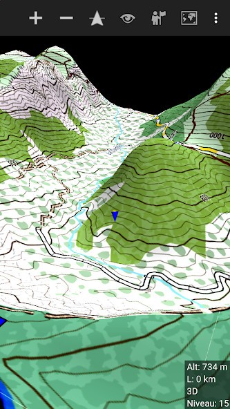
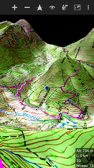
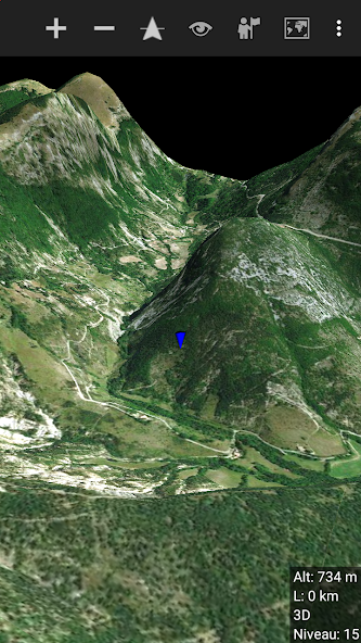
3D map viewer for your hiking trips.

ElevMaps is a powerful GPS tool with a simple and easy user interface.

ElevMaps is a 3D / 2D map viewer for your hiking trips, but not only ;

ElevMaps is perfect also for mountain bike, paraglide, and many outdoors activities ...

The 3D maps are rendered in OpenGL by combining map tile from various sources

with elevation data.

The maps can be displayed like classic map (North up) or with automatic rotation

(GPS orientation and Compass orientation)

ElevMaps is also a great map navigation GPS tool ... You'll be never lost with it !

Current features :

. View online/offline maps in 3D and 2D.

. Download maps areas for offline use.

. View offline maps downloaded with Mobile Atlas Creator (MOBAC)

The atlas format is OSMAND tiles storage.

. View Mapsforge maps/OpenAndroMap maps with different render themes.

. Perfect maps view with zoom level commands IN/OUT and screen fingers gestures integration.

. Import and view OziExplorer maps.

. Download and attach elevations for current downloaded maps.

. Use elevation data in SRTM3 format (stored in device and perfect for big maps)

. Track recording in KML/GPX format.

. Track builder for easy trips preparation in KML/GPX format.

. Track player with hiking mode or flight mode 3D in air (KML/GPX format)

. Import/Export tracks in KML/GPX format.

. Statistics window (altitudes, speed, distance ...)

. Search a place on the map (internet needed)

. And more features coming soon ...

What's New in the Latest Version 1.7.30

Last updated on Mar 21, 2024 V_1_7_30
- increased the upper limit for map elevation lifting factor;
- upgraded the Mapsforge core to version 0.20.0;
Download(7.41MB)
Users also viewed
  • Pozor RADAR!!!

    Pozor RADAR!!!

    1.2 July 7, 2025
  • EasyGaadi

    EasyGaadi

    2.2 July 7, 2025
  • OCR Travel

    OCR Travel

    3.3.1-beta July 7, 2025
  • Ruedataxi taxista

    Ruedataxi taxista

    1.1.9 July 7, 2025
  • Jaltest Telematics Mobile

    Jaltest Telematics Mobile

    22.1.11 July 7, 2025
  • The Art of Motorcycle Maintenance

    The Art of Motorcycle Maintenance

    10.3 July 7, 2025
  • MyJTA

    MyJTA

    5.150.1.1647 July 6, 2025
  • Local Guide

    Local Guide

    1.1 July 6, 2025
  • ABE (GPS communautaire)

    ABE (GPS communautaire)

    1.0.1 July 6, 2025
  • Auto VIN Decode Pro

    Auto VIN Decode Pro

    1.6 July 6, 2025
  • Talkadroid

    Talkadroid

    4.0.6 July 6, 2025
  • Zero200

    Zero200

    6.1.1 July 6, 2025
  • Eateries

    Eateries

    1.2 July 6, 2025
  • Gmoto

    Gmoto

    6.5 July 6, 2025
  • Autostrada A4 Brescia-Padova

    Autostrada A4 Brescia-Padova

    1.4 July 6, 2025
About Privacy Policy Terms of Service Cooking Policy

© Copyright 2017-2025 downzs.com