

Navigation & Maps with GPS for city, traffic,transport: Satellite & Street View.
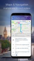
Maps, Navigation & Directions lets you plan your trips, route your travel and find restaurants nearby. Find your current location or search for an address and navigate using googlemaps or OpenStreetMap (OSM) to your destination.
Maps include information from Wikipedia, videos from YouTube, photos Panoramio, street view and weather forecasts.
Whether you need city, satellite, traffic, public transit, cycling or even hiking maps, you can always find your location with Maps, Navigation & Directions!
TRIP PLANNER – World Maps with GPS & Location Tracker
Travel around the world and navigate using any method of transportation:
• Route planner for cars, bikes and walking to any global address
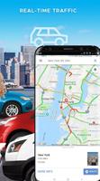
• GPS navigation with local traffic help you find the fastest trip route
• Voice GPS for step-by-step travel directions from the most trusted maps
• Location tracker via GPS (latitude, longitude) or IP-address if available
• Itinerary manager for bus schedules, nearby hotels and more
• Navigation maps with GPS for city, traffic and public transport routes
MAPS
Maps range from satellite maps to bike maps and street view. Traffic conditions and transit maps are also available:
• Street view – See exteriors for museums, restaurants and more
• Traffic maps – See current traffic conditions to avoid traffic jams
• Cycling map with bike routes and contour lines - Plan your next cycling tour
• Walking maps – Explore your city on-foot with detailed walk-friendly maps
• Hiking GPS – Find hiking trails or plan your next backpacking trip
• Satellite view from googlemaps – Enjoy the view from the space
• Maps, Navigation & Directions uses googlemaps and OpenStreetMap (OSM)
TRANSIT – Get Directions & Maps for Over 15,000 Towns & Cities
• Bus routes & tracker – Get directions and maps in over 15K areas
• Train station locations and schedules
• Bike paths for cycling
• Subway maps and stations
FIND NEAR ME – Search to Find:
• Food near you
• Hotels
• Bars near you
• Gas stations
• ATMs
• Addresses (street name & house number, city)
• Nearby city and neighborhood zip codes
Places Around Me: Find hotels, restaurants, shopping, museums, stations, hospitals and more ‘near me’
WEATHER & FORECASTS
• Temperature forecast
• Plan your trip around the weather
MAP FEATURES
Maps include layers of fascinating data like:
★ Photos on map: Photos from worldwide photo sharing database Panoramio and Street view
★ Videos on map: Localized videos on YouTube
★ Wiki on map: Wikipedia guide - read Wikipedia information about selected cities, sights, attractions and interesting places
★ Street view on map: Get a street level view of the world and terrain with street view
★ Webcam Video on map: Webcam video from around the world displayed on maps
Ways to get around anywhere: Explore your city on dozens of maps, including worldwide, street, satellite, traffic, public transit, cycling, walking and hiking even weather maps. Webcam video lets you see weather or traffic is like in the city!
OpenStreetMap (OSM) is a collaborative project to create a free editable map of the world. Two major driving forces behind the establishment and growth of OSM have been restrictions on use or availability of map information across much of the world and the advent of inexpensive portable satellite navigation devices. For more information see www.openstreetmap.org
Maps:
New York, San Francisco, Los Angeles, Orlando, Las Vegas, Washington DC, London, Paris, Amsterdam, Beijing, Tokyo, Munich, Sydney and More!
 Download