• Home
  • Game
    Action Simulation RPG Sports Casual Cards Music Puzzle Shooting Romance
  • Apps
    Business Social Lifestyle Shopping Tools Travel Finance Education News Health
  • Articles

English 中文(简体) 中文(繁体) 한국어 日本語 Português Español Русский العربية Indonesia Deutsch Français ภาษาไทย
Home Apps Travel WalkersGuide
WalkersGuide

WalkersGuide

1
2
3
4
5
Download
  • Version 3.2.2
  • Category Travel
  • Package Name org.walkersguide.android
  • Update Time March 1, 2025
  • Size 6.24MB
About this app

Free navigational aid for the blind and visual impaired based on OpenStreetMap

WalkersGuide is a navigational aid primarily intended for blind and visual impaired pedestrians. It calculates routes and shows nearby points of interest. The project consists of an Android client

and a server component. The latter performs the route calculation.

The map data is provided by OpenStreetMap, a project to create a free map of the world.

Main app features:

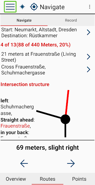
* Based on chosen start and destination the server calculates a route, which is optimized for walkers. Source for start and destination can be the current position, an address, a point of interest or the point history.

* You can prioritise certain way classes to get a more accessible route. For example you may prefer secondary instead of primary streets to avoid complex intersections and reduce traffic noise.

* You get continuous feedback about distance and bearing of the next routing point.

* When you reach an intersection, you can query information about the name, condition and bearing of their streets in realtime.

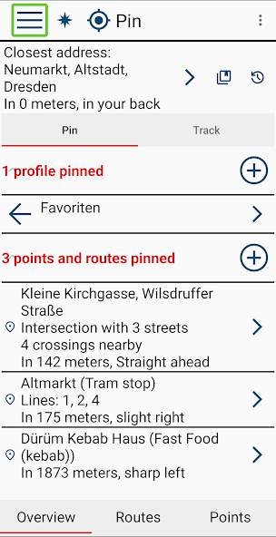
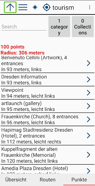
* Besides the routing functionality the application also offers a list of nearby points of interest. This includes shops, public buildings, bus and train stations, intersections, traffic signals and some more.

* You can simulate every distant point like an address in another town or country. The application behaves as if you are really there. So it's possible to explore the next route destination while still at home.

* You can add personal favorites to mark important points, record routes and open GPX files.

The application is fully accessible with Android's screen reader Talkback.

Please visit https://www.WalkersGuide.org for more information.

What's New in the Latest Version 3.2.2

Last updated on Feb 27, 2025 - Direction arrow added in the navigate tab.
- Fixed: Couldn't restore the objects original name after it was renamed at least once.
- Fixed: If the location simulation was enabled and the simulated point was a GPS point then its name was overwritten with its closest address on route calculation.
- Fixed: If your device doesn't support speech input you couldn't navigate to an address from the main menu. Now you can enter the address manually instead.
- Smaller bug fixes and ui improvements
Download(6.24MB)
Users also viewed
  • GetMe2 Wellington Free

    GetMe2 Wellington Free

    1.201 August 28, 2025
  • Scania Technologies

    Scania Technologies

    1.0.8 August 28, 2025
  • Infocar (GPS monitoring)

    Infocar (GPS monitoring)

    2.2.5 August 27, 2025
  • SJ Labs

    SJ Labs

    0.9.5 August 27, 2025
  • Andriders

    Andriders

    3.4 August 26, 2025
  • HolidayIQ

    HolidayIQ

    2.3.4 August 26, 2025
  • Kolumbus

    Kolumbus

    4.26.0 August 25, 2025
  • Gasmoney

    Gasmoney

    1.0 August 25, 2025
  • BerlinMobil

    BerlinMobil

    1.0.59 August 25, 2025
  • Taxi Turismo Taxista

    Taxi Turismo Taxista

    3.5.9 August 25, 2025
  • Domicilio Sr. Juan

    Domicilio Sr. Juan

    2.0 August 24, 2025
  • Desnav GPS Navigation (Navteq)

    Desnav GPS Navigation (Navteq)

    5.0.223 August 24, 2025
  • GPS Navigation & Maps - Scout

    GPS Navigation & Maps - Scout

    8.0 August 24, 2025
  • Airports Maps

    Airports Maps

    1.8 August 24, 2025
  • AtBuss

    AtBuss

    2.0 August 24, 2025
About Privacy Policy Terms of Service Cooking Policy

© Copyright 2017-2025 downzs.com